Fichye:Big Manila.jpg

Fichye orijinal (4 078 × 1 094 piksèl, gwosè fichye a : 1,1 Mio, tip MIME li ye : image/jpeg)

|
FOR CATEGORIES
Republic Act No. 8293 (the IP Code of the Philippines) as it stands today does not contain a freedom of panorama provision that permits free uses of images of copyrighted architectural or artistic works situated in public spaces. Please do not upload image files of such works here, unless their presence or inclusion in the image files is incidental. Architectural or artistic works that are now in public domain should be fine. FOR IMAGE FILES
Copyright warning: A subject in this image is protected by copyright. This image features a copyrighted architectural or artistic work (e.g. monument, sculpture, memorial, or mural), photographed from a public space in the Philippines. There are no freedom of panorama exceptions in the IP Code of the Philippines (R. A. No. 8293), which means that they cannot be photographed freely for anything other than personal purposes, reporting of current events, and educational/teaching purposes. More information: COM:CRT/Philippines#Freedom of panorama. If a copyrighted architectural or artistic work is contained in this image and it is a substantial reproduction, this photo cannot be licensed under a free license, and will be deleted. Framing this image to focus on the copyrighted work is also a copyright violation. Before reusing this content, ensure that you have the right to do so. You are solely responsible for ensuring that you do not infringe someone else's copyrights. See our general disclaimer for more information. |

Rezime
| Deskripsyon |
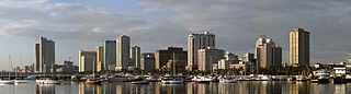
English: A panorama of the Manila skyline, taken from Harbour Square. |
| Dat | |
| Sous | Travay pèsonèl |
| Kreyatè | Mike Gonzalez (TheCoffee) |
| Autres versions |
Derivative works of this file: Manila banner.jpg File:Manila skyline 2007.jpg (original) |
| Lieu de la prise de vue | | Voir cet endroit et d’autres images sur : OpenStreetMap |
|---|
Kondisyon itlizasyon
- Ou gen dwa:
- pou pataje – pou kopye, distribiye epi difize ouvraj la
- pou remiks – pou adapte ouvraj la
- Selon kondisyon sa a yo:
- Rekonèt avèk non otè – Ou dwe bay enfòmasyon apwopriye sou otè a, bay yon lyen pou lisans lan, epi endike si te gen chanjman ki fèt. Ou ka fè sa nan nenpòt fason rezonab, men okenn fason ki sijere ke otè a soutni oswa apwouve itilizasyon ou an.
- Enfòmasyon sa yo ka pataje – Si ou fè rekopye, transfòme, oswa baze sou materyèl sa, ou dwe distribye kontribisyon ou anba menm oswa yon lisans konpatib avèk orijinal la.

|
Ou bay pèmisyon pou kopye, distribye ak/oswa modifye dokiman sa a dapre kondisyon GNU Free Documentation License, Vèsyon. 1.2 oswa nenpòt vèsyon ki pibliye pita pa Free Software Foundation; san okenn Seksyon ki pa ka chanje, pa gen okenn Tèks ak premye paj kouvèti, epi pa gen okenn Tèks Denyè-Kouvèti. Gen yon kopi lisans lan nan seksyon ki rele GNU Free Documentation License. |
Istorik fichye a
Klike sou yon dat/yon lè pou wè fichye a jan li te ye nan moman sa a.
| Dat ak lè | Minyati | Grandè yo | Itilizatè | Komantè | |
|---|---|---|---|---|---|
| Kounye a | 28 mas 2020 à 08:59 | 4 078 × 1 094 (1,1 Mio) | Pandakekok9 | File:Manila skyline 2007.jpg cropped 22 % horizontally, 2 % vertically using CropTool with lossless mode. | |
| 16 jen 2007 à 20:53 | 2 040 × 560 (422 kio) | Dybdal~commonswiki | {{Information |Description=A panorama of the en:Manila skyline, taken from Harbour Square. Photo taken by Mike Gonzalez (en:User:TheCoffee) on April 5, 2007. Released under the GFDL. |Source=Originally from [http://en.wikipedia.org en.wikipedia |
Itilizasyon fichye sa a
paj sa a itilize fichye sa a:
Itilizasyon global fichye a
Wiki sa a yo sèvi ak fichye sa a:
- Itilizasyon sou ar.wikipedia.org
- Itilizasyon sou arz.wikipedia.org
- Itilizasyon sou ast.wikipedia.org
- Itilizasyon sou az.wikipedia.org
- Itilizasyon sou ba.wikipedia.org
- Itilizasyon sou bcl.wikipedia.org
- Itilizasyon sou be-tarask.wikipedia.org
- Itilizasyon sou bn.wikipedia.org
- Itilizasyon sou bn.wikivoyage.org
- Itilizasyon sou ca.wikipedia.org
- Itilizasyon sou cbk-zam.wikipedia.org
- Itilizasyon sou ceb.wikipedia.org
- Itilizasyon sou ce.wikipedia.org
- Itilizasyon sou ckb.wikipedia.org
- Itilizasyon sou crh.wikipedia.org
- Itilizasyon sou cy.wikipedia.org
- Itilizasyon sou da.wikipedia.org
- Itilizasyon sou de.wikipedia.org
- Itilizasyon sou de.wikivoyage.org
- Itilizasyon sou diq.wikipedia.org
- Itilizasyon sou el.wikipedia.org
- Itilizasyon sou en.wikipedia.org
- Itilizasyon sou en.wikivoyage.org
- Itilizasyon sou eu.wikipedia.org
- Itilizasyon sou fiu-vro.wikipedia.org
- Itilizasyon sou fi.wikipedia.org
- Itilizasyon sou fr.wikivoyage.org
- Itilizasyon sou ga.wikipedia.org
- Itilizasyon sou gd.wikipedia.org
- Itilizasyon sou gl.wikipedia.org
- Itilizasyon sou gn.wikipedia.org
- Itilizasyon sou ha.wikipedia.org
- Itilizasyon sou he.wikipedia.org
- Itilizasyon sou he.wikivoyage.org
- Itilizasyon sou hu.wikipedia.org
- Itilizasyon sou hyw.wikipedia.org
Gade plis itilizasyon global fichye sa a.