Fichye:Snow in Coastal North Carolina 2010-02-14.jpg

Dimansyon previzyalizasyon sa a : 600 × 600 piksèl. Lòt rezolisyon yo: 240 × 240 piksèl | 480 × 480 piksèl | 720 × 720 piksèl.
Fichye orijinal (720 × 720 piksèl, gwosè fichye a : 455 kio, tip MIME li ye : image/jpeg)
Rezime
| Deskripsyon |
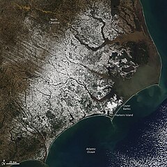
English: With miles of sandy beaches and generally good weather, coastal North Carolina isn’t a place you would usually expect to find snow. But the view from the Moderate Resolution Imaging Spectroradiometer (MODIS) on NASA’s Aqua satellite on February 14, 2010, shows snow extending to the Outer Banks. The sandy islands, normally pale tan, are bright white in this image. Harkers Island received 8.8 inches of snow, reported CNN. The snow fell in a winter storm that moved across the southern United States from Texas to the Atlantic Coast on February 12-13. |
| Dat | |
| Sous | http://earthobservatory.nasa.gov/NaturalHazards/view.php?id=42698&src=nha |
| Kreyatè | NASA |
| Autres versions |
|

Kondisyon itlizasyon
| Ce fichier provient de la NASA. Sauf exception, les documents créés par la NASA ne sont pas soumis à copyright. Pour plus d'informations, voir la politique de copyright de la NASA. | ||
 |
Attention :
|
Istorik fichye a
Klike sou yon dat/yon lè pou wè fichye a jan li te ye nan moman sa a.
| Dat ak lè | Minyati | Grandè yo | Itilizatè | Komantè | |
|---|---|---|---|---|---|
| Kounye a | 16 fevriye 2010 à 19:42 | | 720 × 720 (455 kio) | Captain-tucker | {{Information |Description={{en|With miles of sandy beaches and generally good weather, coastal North Carolina isn’t a place you would usually expect to find snow. But the view from the Moderate Resolution Imaging Spectroradiometer (MODIS) on NASA’s A |
Itilizasyon fichye sa a
paj sa a itilize fichye sa a:
Itilizasyon global fichye a
Wiki sa a yo sèvi ak fichye sa a:
- Itilizasyon sou ar.wikipedia.org
- Itilizasyon sou ary.wikipedia.org
- Itilizasyon sou arz.wikipedia.org
- Itilizasyon sou ast.wikipedia.org
- Itilizasyon sou ca.wikipedia.org
- Itilizasyon sou cy.wikipedia.org
- Itilizasyon sou dag.wikipedia.org
- Itilizasyon sou de.wikivoyage.org
- Itilizasyon sou diq.wikipedia.org
- Itilizasyon sou eo.wikipedia.org
- Itilizasyon sou eu.wikipedia.org
- Itilizasyon sou fr.wikinews.org
- Itilizasyon sou fr.wikivoyage.org
- Itilizasyon sou ga.wikipedia.org
- Itilizasyon sou gl.wikipedia.org
- Itilizasyon sou ha.wikipedia.org
- Itilizasyon sou he.wikipedia.org
- Itilizasyon sou hy.wikipedia.org
- Itilizasyon sou ia.wikipedia.org
- Itilizasyon sou ig.wikipedia.org
- Itilizasyon sou ku.wikipedia.org
- Itilizasyon sou mhr.wikipedia.org
- Itilizasyon sou nn.wikipedia.org
- Itilizasyon sou oc.wikipedia.org
- Itilizasyon sou os.wikipedia.org
- Itilizasyon sou pap.wikipedia.org
- Itilizasyon sou pl.wikipedia.org
- Itilizasyon sou ru.wikinews.org
- Itilizasyon sou sr.wikipedia.org
- Itilizasyon sou tg.wikipedia.org
- Itilizasyon sou tl.wikipedia.org
- Itilizasyon sou tt.wikipedia.org
- Itilizasyon sou vec.wikipedia.org
- Itilizasyon sou vi.wikipedia.org
- Itilizasyon sou www.wikidata.org