Fichye:Georgia topographic map-fr.svg

Taille de cet aperçu PNG pour ce fichier SVG : 707 × 385 piksèl. Lòt rezolisyon yo: 320 × 174 piksèl | 640 × 349 piksèl | 1 024 × 558 piksèl | 1 280 × 697 piksèl | 2 560 × 1 394 piksèl.
Fichye orijinal (Fichye SVG, rezolisyon de 707 × 385 piksèl, gwosè fichye : 3,52 Mio)
Rezime
| Deskripsyon |
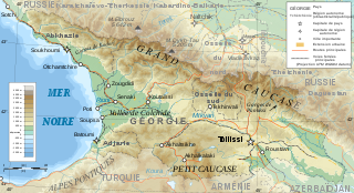
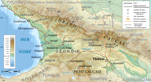
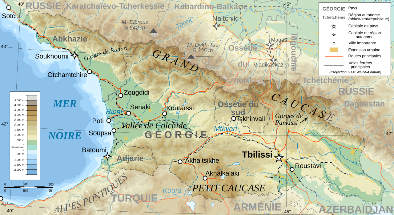
Deutsch: Topographische Karte von Georgien, französische Version English: Topographic map in French of Georgia Français : Carte topographique en français de la Géorgie |
| Dat | |
| Sous |
English: Own work ; Topographic data from the NASA Shuttle Radar Topography Mission (SRTM3 v.2) (public domain) edited with 3DEM, reprojected in UTM with GDAL (GDAL), and vectorized with Inkscape ; UTM projection ; WGS84 datum ; shaded relief (composite image of N-W, W and N lightning positions) ; Reference used for the additional data : * Rivers, cities, railroads, routes, bathymetry : Demis add-on for World Wind (see the approval e-mail and the Demis forum) ; * Borders and coast : World data bank II ; Approximate scale of topographic data : 1:1,463,000 ; Note : The shaded relief is a raster image embedded in the SVG file. Français : Création personnelle ; Données topographiques de la NASA Shuttle Radar Topography Mission (SRTM3 v.2) (domaine public) éditées avec 3DEM, reprojetées en UTM avec GDAL et vectorisées avec Inkscape ; projection UTM ; WGS84 datum ; relief ombré (image composite d'éclairages du N-O, O et N) ; Références utilisées pour les données complémentaires : * Rivières, villes, chemins de fers, routes, bathymétrie : Demis add-on for World Wind (cf. l'e-mail d'approbation de Demis et le Demis forum) ; * Frontières et côtes : World data bank II ; Échelle approximative des données topographiques : 1:1 463 000 ; Note : Le relief ombré est une image bitmap embarquée dans le fichier SVG. |
| Kreyatè | Bourrichon - fr:Bourrichon |
| Pèmisyon : (Resèvi ak fichye sa a) |
GFDL / Attribution and Share-Alike required |
| Autres versions |
Œuvres dérivées de ce fichier : Georgia topographic map-blanked.svg
|


|
Ce fichier SVG contient du texte encapsulé pouvant facilement être traduit dans votre langue en utilisant n'importe quel éditeur de fichier SVG ou de texte, ou par l'outil de traduction de fichiers SVG. Pour plus d'informations, voir : A propos de la traduction des fichiers SVG. |
Kondisyon itlizasyon
Moi, en tant que détenteur des droits d’auteur sur cette œuvre, je la publie sous les licences suivantes :

|
Ou bay pèmisyon pou kopye, distribye ak/oswa modifye dokiman sa a dapre kondisyon GNU Free Documentation License, Vèsyon. 1.2 oswa nenpòt vèsyon ki pibliye pita pa Free Software Foundation; san okenn Seksyon ki pa ka chanje, pa gen okenn Tèks ak premye paj kouvèti, epi pa gen okenn Tèks Denyè-Kouvèti. Gen yon kopi lisans lan nan seksyon ki rele GNU Free Documentation License. |
This file is licensed under the Creative Commons Attribution-Share Alike 4.0 International, 3.0 Unported, 2.5 Generic, 2.0 Generic and 1.0 Generic license.
- Ou gen dwa:
- pou pataje – pou kopye, distribiye epi difize ouvraj la
- pou remiks – pou adapte ouvraj la
- Selon kondisyon sa a yo:
- Rekonèt avèk non otè – Ou dwe bay enfòmasyon apwopriye sou otè a, bay yon lyen pou lisans lan, epi endike si te gen chanjman ki fèt. Ou ka fè sa nan nenpòt fason rezonab, men okenn fason ki sijere ke otè a soutni oswa apwouve itilizasyon ou an.
- Enfòmasyon sa yo ka pataje – Si ou fè rekopye, transfòme, oswa baze sou materyèl sa, ou dwe distribye kontribisyon ou anba menm oswa yon lisans konpatib avèk orijinal la.
Chwazi lisans ou vle a.
Istorik fichye a
Klike sou yon dat/yon lè pou wè fichye a jan li te ye nan moman sa a.
| Dat ak lè | Minyati | Grandè yo | Itilizatè | Komantè | |
|---|---|---|---|---|---|
| Kounye a | 13 janvye 2020 à 14:57 | | 707 × 385 (3,52 Mio) | Takhirgeran Umar | clarification |
| 30 mas 2009 à 21:43 |  | 707 × 385 (3,52 Mio) | Bourrichon | +Daguestan | |
| 13 mas 2009 à 18:09 |  | 707 × 385 (3,52 Mio) | Bourrichon | + longitude | |
| 13 mas 2009 à 18:01 |  | 707 × 385 (3,52 Mio) | Bourrichon | -Iran | |
| 13 mas 2009 à 17:38 |  | 707 × 385 (4,55 Mio) | Bourrichon | + Gorges | |
| 13 mas 2009 à 17:32 |  | 707 × 385 (4,52 Mio) | Bourrichon | == Summary == {{Information |Description={{de|Topographische Karte von Georgien, französische Version}}{{en|Topographic map in French of Georgia}}{{fr|Carte topographique en français de la [[:fr:Géorgie (pays)|Géorgie] |
Itilizasyon fichye sa a
paj sa a itilize fichye sa a:
Itilizasyon global fichye a
Wiki sa a yo sèvi ak fichye sa a:
- Itilizasyon sou ab.wikipedia.org
- Itilizasyon sou cv.wikipedia.org
- Itilizasyon sou fr.wikipedia.org
- Géorgie (pays)
- Géographie de la Géorgie
- Projet:Cartographie/Cartes standards/Pays
- Wikipédia:Atelier graphique/Cartes/Archives/mars 2009
- Wikipédia:Atelier graphique/Cartes/Archives/avril 2009
- Wikipédia:Atelier graphique/Cartes/Archives/Demandes mises en sommeil/Europe
- Liste des villes jumelées de Géorgie
- Itilizasyon sou uz.wikipedia.org
- Itilizasyon sou wo.wikipedia.org