Fichye:Granger Stage Station.jpg

Dimansyon previzyalizasyon sa a : 800 × 559 piksèl. Lòt rezolisyon yo: 320 × 224 piksèl | 640 × 447 piksèl | 956 × 668 piksèl.
Fichye orijinal (956 × 668 piksèl, gwosè fichye a : 73 kio, tip MIME li ye : image/jpeg)
|
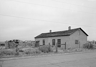
Ceci est une photographie d’un monument référencé dans le National Register of Historic Places des États-Unis sous le numéro 70000678. |
| Lieu de la prise de vue | | Voir cet endroit et d’autres images sur : OpenStreetMap |
|---|
| Deskripsyon |
English: Front of the Granger Station, a former stagecoach station located along Old U.S. Route 30 in Granger, Wyoming, United States. Built in 1856, the station is listed on the National Register of Historic Places. |
|||||
| Dat | Date inconnue | |||||
| Sous | Library of Congress, Prints and Photograph Division HABS: WYO,19-GRANG,1-1 | |||||
| Kreyatè | Auteur inconnu | |||||
| Pèmisyon : (Resèvi ak fichye sa a) |
|


|
Cette image est disponible sur la Prints and Photographs division de la Bibliothèque du Congrès des États-Unis sous le numéro d’identification hhh.wy0029.
Ce bandeau n’indique rien sur le statut de l’œuvre au regard du droit d'auteur. Un bandeau de droit d’auteur est requis. Voir Commons:À propos des licences pour plus d’informations.
|
Istorik fichye a
Klike sou yon dat/yon lè pou wè fichye a jan li te ye nan moman sa a.
| Dat ak lè | Minyati | Grandè yo | Itilizatè | Komantè | |
|---|---|---|---|---|---|
| Kounye a | 28 avril 2009 à 18:20 | | 956 × 668 (73 kio) | Cropbot | upload cropped version, operated by User:Finavon. Summary: border cropped |
| 25 avril 2009 à 15:32 |  | 1 024 × 728 (83 kio) | Nyttend | {{Location|41|35|25|N|109|58|8|W}} {{Information |Description={{en|Front of the {{w|Granger Station}}, a former {{w|stagecoach}} station located along Old {{w|U.S. Route 30}} in {{w|Granger, Wyoming|Granger}}, {{w|Wyoming}}, {{w|United States}}. Built in |
Itilizasyon fichye sa a
Pa gen okenn paj ki itilize dosye sa a.
Itilizasyon global fichye a
Wiki sa a yo sèvi ak fichye sa a:
- Itilizasyon sou azb.wikipedia.org
- Itilizasyon sou de.wikipedia.org
- Itilizasyon sou en.wikipedia.org
- Itilizasyon sou fa.wikipedia.org
- Itilizasyon sou pt.wikipedia.org
- Itilizasyon sou sh.wikipedia.org
- Itilizasyon sou sr.wikipedia.org
- Itilizasyon sou sv.wikipedia.org
- Itilizasyon sou uk.wikipedia.org
- Itilizasyon sou zh-min-nan.wikipedia.org