Fichye:Majuro Satellite.PNG

Dimansyon previzyalizasyon sa a : 800 × 416 piksèl. Lòt rezolisyon yo: 320 × 167 piksèl | 640 × 333 piksèl | 1 024 × 533 piksèl | 1 918 × 998 piksèl.
Fichye orijinal (1 918 × 998 piksèl, gwosè fichye a : 5,49 Mio, tip MIME li ye : image/png)
Rezime
| Deskripsyon |
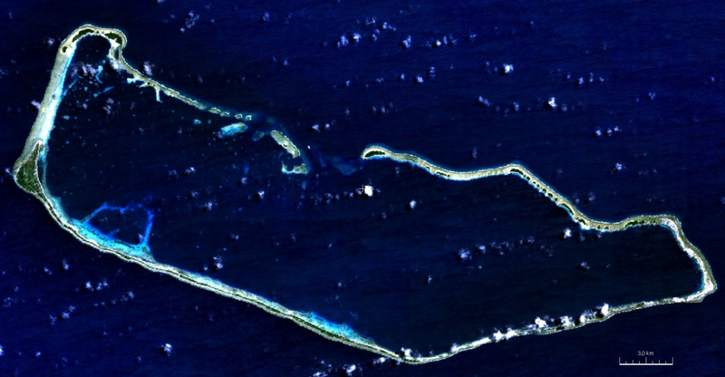
English: visible color satellite image of Majuro Atoll, Marshall Islands, Pacific Ocean |
| Dat | |
| Sous | NASA World Wind Screenshot (visible color) |
| Kreyatè | NASA |
Kondisyon itlizasyon
| Cette image est dans le domaine public car elle est constituée d'une capture d'écran du logiciel World Wind de la NASA qui utilise des données du domaine public, comme Blue Marble, MODIS, Landsat, SRTM, USGS ou GLOBE.
|
 |
Istorik fichye a
Klike sou yon dat/yon lè pou wè fichye a jan li te ye nan moman sa a.
| Dat ak lè | Minyati | Grandè yo | Itilizatè | Komantè | |
|---|---|---|---|---|---|
| Kounye a | 7 out 2011 à 20:17 | | 1 918 × 998 (5,49 Mio) | Ratzer | {{Information |Description ={{en|1=true color satellite image of Majuro Atoll, Marshall Islands, Pacific Ocean}} |Source =NASA World Wind Screenshot (true color) |Author =NASA |Date =2000 |Permission = |other_versions = }} |
Itilizasyon fichye sa a
Pa gen okenn paj ki itilize dosye sa a.
Itilizasyon global fichye a
Wiki sa a yo sèvi ak fichye sa a:
- Itilizasyon sou ar.wikipedia.org
- Itilizasyon sou be.wikipedia.org
- Itilizasyon sou bn.wikipedia.org
- Itilizasyon sou ceb.wikipedia.org
- Itilizasyon sou de.wikipedia.org
- Itilizasyon sou en.wikipedia.org
- Itilizasyon sou eo.wikipedia.org
- Itilizasyon sou es.wikipedia.org
- Itilizasyon sou fi.wikipedia.org
- Itilizasyon sou fr.wikipedia.org
- Itilizasyon sou gn.wikipedia.org
- Itilizasyon sou he.wikipedia.org
- Itilizasyon sou hi.wikipedia.org
- Itilizasyon sou id.wikipedia.org
- Itilizasyon sou ja.wikipedia.org
- Itilizasyon sou lt.wikipedia.org
- Itilizasyon sou lv.wikipedia.org
- Itilizasyon sou ml.wikipedia.org
- Itilizasyon sou nl.wikipedia.org
- Itilizasyon sou pl.wikipedia.org
- Itilizasyon sou sat.wikipedia.org
- Itilizasyon sou sd.wikipedia.org
- Itilizasyon sou sh.wikipedia.org
- Itilizasyon sou sl.wikipedia.org
- Itilizasyon sou sr.wikipedia.org
- Itilizasyon sou ur.wikipedia.org
- Itilizasyon sou vep.wikipedia.org
- Itilizasyon sou www.wikidata.org
- Itilizasyon sou xmf.wikipedia.org
- Itilizasyon sou zh.wikivoyage.org