Fichye:Map of Alaska highlighting Yakutat City and Borough.svg

Taille de cet aperçu PNG pour ce fichier SVG : 800 × 423 piksèl. Lòt rezolisyon yo: 320 × 169 piksèl | 640 × 338 piksèl | 1 024 × 541 piksèl | 1 280 × 677 piksèl | 2 560 × 1 353 piksèl | 1 470 × 777 piksèl.
Fichye orijinal (Fichye SVG, rezolisyon de 1 470 × 777 piksèl, gwosè fichye : 789 kio)
Rezime
| Deskripsyon |
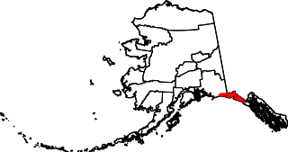
English: This is a locator map showing Yakutat City and Borough in Alaska |
| Dat | |
| Sous |
Travay pèsonèl: English: The maps use data from nationalatlas.gov, specifically countyp020.tar.gz on the Raw Data Download page. The maps also use state outline data from statesp020.tar.gz. The Florida maps use hydrogm020.tar.gz to display Lake Okeechobee. |
| Kreyatè | David Benbennick |
| SVG information | Cette carte a été créée avec Adobe Illustrator, et avec Inkscape. |
Kondisyon itlizasyon
| Moi, propriétaire des droits d’auteur sur cette œuvre, la place dans le domaine public. Ceci s'applique dans le monde entier. Dans certains pays, ceci peut ne pas être possible ; dans ce cas : J’accorde à toute personne le droit d’utiliser cette œuvre dans n’importe quel but, sans aucune condition, sauf celles requises par la loi. |
Istorik fichye a
Klike sou yon dat/yon lè pou wè fichye a jan li te ye nan moman sa a.
| Dat ak lè | Minyati | Grandè yo | Itilizatè | Komantè | |
|---|---|---|---|---|---|
| Kounye a | 24 out 2018 à 20:32 | | 1 470 × 777 (789 kio) | NordNordWest | correct |
| 13 fevriye 2009 à 15:49 |  | 1 470 × 777 (370 kio) | Niagara | correct | |
| 5 mas 2006 à 19:30 |  | 1 470 × 777 (338 kio) | David Benbennick | {{subst:User:Dbenbenn/clm|county=Yakutat City and Borough|state=Alaska|type=borough and census area}} |
Itilizasyon fichye sa a
paj sa a itilize fichye sa a:
Itilizasyon global fichye a
Wiki sa a yo sèvi ak fichye sa a:
- Itilizasyon sou ar.wikipedia.org
- Itilizasyon sou arz.wikipedia.org
- Itilizasyon sou azb.wikipedia.org
- Itilizasyon sou bpy.wikipedia.org
- Itilizasyon sou ca.wikipedia.org
- Itilizasyon sou ceb.wikipedia.org
- Itilizasyon sou ce.wikipedia.org
- Itilizasyon sou cy.wikipedia.org
- Itilizasyon sou de.wikipedia.org
- Itilizasyon sou en.wikipedia.org
- List of boroughs and census areas in Alaska
- Yakutat, Alaska
- Disenchantment Bay
- Yakutat Bay
- Russell Fiord
- Bering Glacier
- Vitus Lake
- Yahtse Glacier
- Guyot Glacier
- Wikipedia:WikiProject Alaska
- Mount Alverstone
- Mount Steller (Chugach Mountains)
- Fairweather Range
- Haenke Island
- Variegated Glacier
- New Russia (trading post)
- User:Nyttend/County templates/AK
- Template:Yakutat Borough, Alaska
- Mount Root
- Template:YakutatAK-geo-stub
- National Register of Historic Places listings in Yakutat, Alaska
- Situk River
- Cape Yakataga, Alaska
- Yahtse River
- Agassiz Glacier (Alaska)
- Yakutat Glacier
- Brabazon Range
- Mount Aylesworth
- Mount Armour
- Mount Duff (Yakutat)
- Mount Jetté
- Mount Herbert (Yakutat)
- Mount Lodge (Yakutat)
- Mount Hay (Yakutat)
- Mount Barnard (Alsek Ranges)
- Mount Harris
- User:AridCeption/sandbox
- Tyndall Glacier (Alaska)
- Itilizasyon sou eo.wikipedia.org
- Itilizasyon sou es.wikipedia.org
Gade plis itilizasyon global fichye sa a.