Fichye:New 2000 black percent.gif

Dimansyon previzyalizasyon sa a : 776 × 600 piksèl. Lòt rezolisyon yo: 311 × 240 piksèl | 621 × 480 piksèl | 994 × 768 piksèl | 1 280 × 989 piksèl | 2 604 × 2 012 piksèl.
Fichye orijinal (2 604 × 2 012 piksèl, gwosè fichye a : 649 kio, tip MIME li ye : image/gif)
Rezime

|
Cette image (de type ethnographic map) devrait être recréée dans un format vectoriel, en tant que fichier SVG. Cela offrirait plusieurs avantages : voir Commons:Media for cleanup pour plus d'informations. Si une version SVG de cette image est déjà disponible, merci de bien vouloir l'envoyer. Après cela, remplacez ce modèle par {{vector version available|nouveau nom d'image.svg}}.
|
| Deskripsyon |
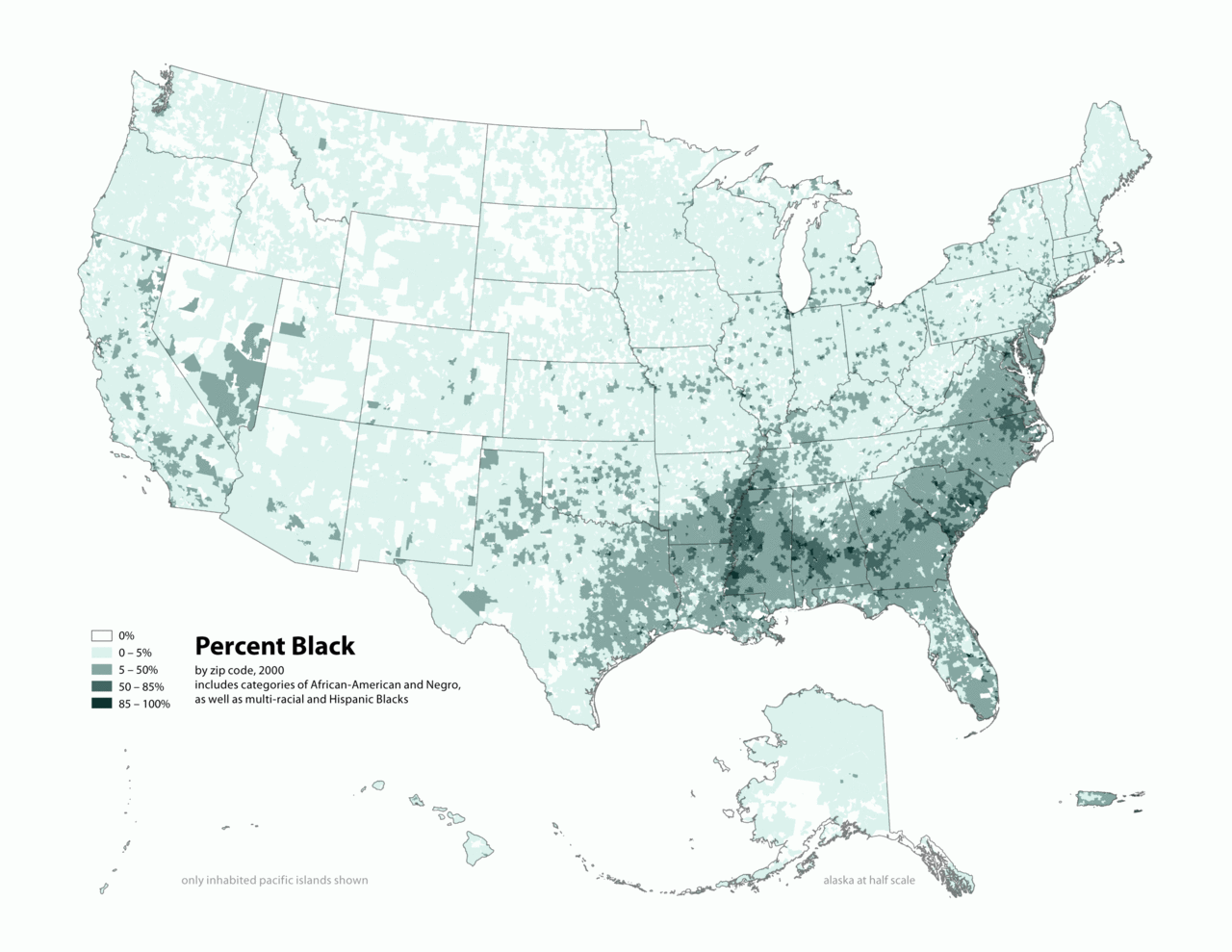
English: Map of contiguous US, showing percentage of population self-reported as "Black," by census tract, 2000. Data source: US Census. |
| Dat | 3 avril 2006 (date de téléversement originale) |
| Sous | Transferred from en.wikipedia to Commons by O'Dea. |
| Kreyatè | Original téléversé par Citynoise sur Wikipedya anglais. |
Kondisyon itlizasyon
Ce fichier est disponible selon les termes de la licence Creative Commons Attribution – Partage dans les Mêmes Conditions 2.5 Générique
- Ou gen dwa:
- pou pataje – pou kopye, distribiye epi difize ouvraj la
- pou remiks – pou adapte ouvraj la
- Selon kondisyon sa a yo:
- Rekonèt avèk non otè – Ou dwe bay enfòmasyon apwopriye sou otè a, bay yon lyen pou lisans lan, epi endike si te gen chanjman ki fèt. Ou ka fè sa nan nenpòt fason rezonab, men okenn fason ki sijere ke otè a soutni oswa apwouve itilizasyon ou an.
- Enfòmasyon sa yo ka pataje – Si ou fè rekopye, transfòme, oswa baze sou materyèl sa, ou dwe distribye kontribisyon ou anba menm oswa yon lisans konpatib avèk orijinal la.
Journal des téléversements d’origine
The original description page was here. All following user names refer to en.wikipedia.
- 2010-05-01 19:15 Citynoise 2604×2012× (664072 bytes) Added Alaska, Hawaii, and Territories. Also changed from tracts to zip codes.
- 2006-04-03 02:04 Citynoise 1012×691× (78990 bytes) Map of contiguous US, showing percentage of population self-reported as "Black," by census tract, 2000. Data source: US Census. I am the designer and creator of this map and license it under the Creative Commons Attribution ShareAlike 2.5 License. s
Category:Census maps of the United States Category:Maps illustrating African American history Category:African American history
Istorik fichye a
Klike sou yon dat/yon lè pou wè fichye a jan li te ye nan moman sa a.
| Dat ak lè | Minyati | Grandè yo | Itilizatè | Komantè | |
|---|---|---|---|---|---|
| Kounye a | 31 desanm 2011 à 02:48 | | 2 604 × 2 012 (649 kio) | Spideog | {{Information |Description={{en|en:Category:Census maps of the United States en:Category:Maps illustrating African American history en:Category:African American history}} |Source=Transferred from [http://en.wikipedia.org en.wikipedia]; t |
Itilizasyon fichye sa a
paj sa a itilize fichye sa a:
Itilizasyon global fichye a
Wiki sa a yo sèvi ak fichye sa a:
- Itilizasyon sou af.wikipedia.org
- Itilizasyon sou ar.wikipedia.org
- Itilizasyon sou cs.wikipedia.org
- Itilizasyon sou de.wikipedia.org
- Itilizasyon sou diq.wikipedia.org
- Itilizasyon sou en.wikipedia.org
- Itilizasyon sou fa.wikipedia.org
- Itilizasyon sou fr.wikipedia.org
- Itilizasyon sou fy.wikipedia.org
- Itilizasyon sou he.wikipedia.org
- Itilizasyon sou lfn.wikipedia.org
- Itilizasyon sou pt.wikipedia.org
- Itilizasyon sou ro.wikipedia.org
- Itilizasyon sou ru.wikipedia.org
- Itilizasyon sou test.wikipedia.org
- Itilizasyon sou tl.wikipedia.org
- Itilizasyon sou ur.wikipedia.org
- Itilizasyon sou uz.wikipedia.org