Fichye:Southold-town-map.gif
Pa genyen rezolisyon ki pi wo ki disponib.
Southold-town-map.gif (575 × 425 piksèl, gwosè fichye a : 51 kio, tip MIME li ye : image/gif)
Rezime
| Deskripsyon | |
| Dat | |
| Sous | http://factfinder.census.gov |
| Kreyatè | United States Census Bureau |
| Pèmisyon : (Resèvi ak fichye sa a) |
Public domain |
Kondisyon itlizasyon
This image or file is a work of a United States Census Bureau employee, taken or made as part of that person's official duties. As a work of the U.S. federal government, the image is in the public domain.
|
 |
Journal des téléversements d’origine
Transféré de en.wikipedia à Commons par Cocoloi utilisant CommonsHelper.
La page de description originale était ici. Tous les noms d'utilisateur qui suivent se rapportent à en.wikipedia.
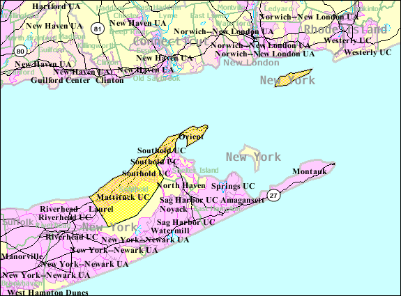
- 2007-10-22 10:57 Americasroof 575×425× (52662 bytes) [[Southold, New York]] map from U.S. Census
Istorik fichye a
Klike sou yon dat/yon lè pou wè fichye a jan li te ye nan moman sa a.
| Dat ak lè | Minyati | Grandè yo | Itilizatè | Komantè | |
|---|---|---|---|---|---|
| Kounye a | 9 me 2009 à 12:30 | | 575 × 425 (51 kio) | File Upload Bot (Magnus Manske) | {{BotMoveToCommons|en.wikipedia|year={{subst:CURRENTYEAR}}|month={{subst:CURRENTMONTHNAME}}|day={{subst:CURRENTDAY}}}} {{Information |Description={{en|en:U.S. Census 2000 reference map for en:Southold, New York}} |Source=Transferred from [htt |
Itilizasyon fichye sa a
paj sa a itilize fichye sa a:
Itilizasyon global fichye a
Wiki sa a yo sèvi ak fichye sa a:
- Itilizasyon sou azb.wikipedia.org
- Itilizasyon sou ceb.wikipedia.org
- Itilizasyon sou de.wikipedia.org
- Itilizasyon sou en.wikipedia.org
- Itilizasyon sou es.wikipedia.org
- Itilizasyon sou fr.wikipedia.org
- Itilizasyon sou www.wikidata.org
- Itilizasyon sou zh.wikipedia.org