Fichye:Ancient Egypt map-fr.svg

Taille de cet aperçu PNG pour ce fichier SVG : 293 × 598 piksèl. Lòt rezolisyon yo: 117 × 240 piksèl | 235 × 480 piksèl | 376 × 768 piksèl | 501 × 1 024 piksèl | 1 003 × 2 048 piksèl | 1 577 × 3 219 piksèl.
Fichye orijinal (Fichye SVG, rezolisyon de 1 577 × 3 219 piksèl, gwosè fichye : 417 kio)
Rezime
Cette image vectorielle non W3C-spécifiée a été créée avec Inkscape .
| Deskripsyon |
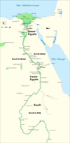
Français : Carte de l'Egypte antique, montrant le Nil jusqu'à la cinquième cataracte et les principaux sites de la période dynastique (v. 3150-30 av. J.-C.). Le Caire et Jérusalem sont représentées comme villes de référence. |
| Dat | (original en anglais); 2009-02-20 (traduction française) |
| Sous | Traduction de File:Ancient Egypt map-en.svg |
| Kreyatè | Jeff Dahl (original en anglais); Bibi Saint-Pol (traduction française) |
| Autres versions |
[]
|


|
This SVG file contains embedded text that can be translated into your language, using any capable SVG editor, text editor or the SVG Translate tool. For more information see: About translating SVG files. |
Kondisyon itlizasyon
Moi, en tant que détenteur des droits d’auteur sur cette œuvre, je la publie sous les licences suivantes :

|
Ou bay pèmisyon pou kopye, distribye ak/oswa modifye dokiman sa a dapre kondisyon GNU Free Documentation License, Vèsyon. 1.2 oswa nenpòt vèsyon ki pibliye pita pa Free Software Foundation; san okenn Seksyon ki pa ka chanje, pa gen okenn Tèks ak premye paj kouvèti, epi pa gen okenn Tèks Denyè-Kouvèti. Gen yon kopi lisans lan nan seksyon ki rele GNU Free Documentation License. |
This file is licensed under the Creative Commons Attribution-Share Alike 4.0 International, 3.0 Unported, 2.5 Generic, 2.0 Generic and 1.0 Generic license.
- Ou gen dwa:
- pou pataje – pou kopye, distribiye epi difize ouvraj la
- pou remiks – pou adapte ouvraj la
- Selon kondisyon sa a yo:
- Rekonèt avèk non otè – Ou dwe bay enfòmasyon apwopriye sou otè a, bay yon lyen pou lisans lan, epi endike si te gen chanjman ki fèt. Ou ka fè sa nan nenpòt fason rezonab, men okenn fason ki sijere ke otè a soutni oswa apwouve itilizasyon ou an.
- Enfòmasyon sa yo ka pataje – Si ou fè rekopye, transfòme, oswa baze sou materyèl sa, ou dwe distribye kontribisyon ou anba menm oswa yon lisans konpatib avèk orijinal la.
Chwazi lisans ou vle a.
Istorik fichye a
Klike sou yon dat/yon lè pou wè fichye a jan li te ye nan moman sa a.
| Dat ak lè | Minyati | Grandè yo | Itilizatè | Komantè | |
|---|---|---|---|---|---|
| Kounye a | 15 me 2011 à 11:44 | | 1 577 × 3 219 (417 kio) | Bibi Saint-Pol | fix typo |
| 20 fevriye 2009 à 13:36 |  | 1 577 × 3 219 (414 kio) | Bibi Saint-Pol | == {{int:filedesc}} == {{inkscape}} {{Information |Description= {{fr|Carte de l'Egypte antique, montrant le Nil jusqu'à la cinquième cataracte et les principaux sites de la période dynastique (v. 3150-30 av. J.-C.). Le Caire et Jérusalem sont représe |
Itilizasyon fichye sa a
paj sa a itilize fichye sa a:
Itilizasyon global fichye a
Wiki sa a yo sèvi ak fichye sa a:
- Itilizasyon sou fr.wikipedia.org
- Antiquité
- Memphis (Égypte)
- Symbolique des couleurs dans l'Égypte antique
- Basse-Égypte
- Haute-Égypte
- Géographie de l'Égypte antique
- Première Période intermédiaire
- Culture de Nagada
- Égypte antique
- Campagnes d'Auguste en Afrique et en Arabie
- Legio II Traiana Fortis
- Mythes royaux de légitimation dans l'Égypte antique
- Itilizasyon sou fr.wikiversity.org
- Itilizasyon sou fr.wiktionary.org
- Itilizasyon sou mg.wikipedia.org
- Itilizasyon sou oc.wikipedia.org