Fichye:East entry to Vernal, Utah, on US-40 (7063605801).jpg

Dimansyon previzyalizasyon sa a : 800 × 532 piksèl. Lòt rezolisyon yo: 320 × 213 piksèl | 640 × 425 piksèl | 1 024 × 680 piksèl | 1 280 × 850 piksèl | 1 600 × 1 063 piksèl.
Fichye orijinal (1 600 × 1 063 piksèl, gwosè fichye a : 433 kio, tip MIME li ye : image/jpeg)
.jpg)
Rezime
| Deskripsyon |
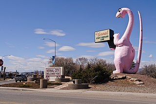
The pink sauropod greets visitors to Vernal, the main population center in northeastern Utah. This is indeed Utah's dinosaur country, because Dinosaur National Monument is only ten miles or so to the east, just north of the town of Jensen. It is also the only reason I decided to drive all the way out here. US-40 was the main east-west highway, also known as the Lincoln Highway, that stretched all the way from San Francisco to Atlantic City. Today, the sections west of Park City have been switched to I-80, but in this area, US-40 still plays an important role as it is still the only direct connection between Salt Lake City and Denver. (I-70 had been intended to supersede US-40 through Utah and Colorado, but I-70 ended up being re-oriented southwest to point toward Las Vegas and Los Angeles instead.) |
| Dat | Prise le 15 mas 2012, 14:07 |
| Sous | East entry to Vernal, Utah, on US-40 |
| Kreyatè | InSapphoWeTrust from Los Angeles, California, USA |
| Lieu de la prise de vue | | Voir cet endroit et d’autres images sur : OpenStreetMap |
|---|
.jpg¶ms=040.456237_N_-109.511289_E_globe:Earth_type:camera_source:Flickr_&language=ht)
Kondisyon itlizasyon
Ce fichier est disponible selon les termes de la licence Creative Commons Attribution – Partage dans les Mêmes Conditions 2.0 Générique
- Ou gen dwa:
- pou pataje – pou kopye, distribiye epi difize ouvraj la
- pou remiks – pou adapte ouvraj la
- Selon kondisyon sa a yo:
- Rekonèt avèk non otè – Ou dwe bay enfòmasyon apwopriye sou otè a, bay yon lyen pou lisans lan, epi endike si te gen chanjman ki fèt. Ou ka fè sa nan nenpòt fason rezonab, men okenn fason ki sijere ke otè a soutni oswa apwouve itilizasyon ou an.
- Enfòmasyon sa yo ka pataje – Si ou fè rekopye, transfòme, oswa baze sou materyèl sa, ou dwe distribye kontribisyon ou anba menm oswa yon lisans konpatib avèk orijinal la.
| Cette image, qui provient de Flickr, a été vérifiée le 27 janvier 2013 par l'administrateur ou l'utilisateur de confiance (trusted user) File Upload Bot (Magnus Manske), qui a confirmé qu'à cette date, elle était publiée sur Flickr sous cette licence. |
Istorik fichye a
Klike sou yon dat/yon lè pou wè fichye a jan li te ye nan moman sa a.
| Dat ak lè | Minyati | Grandè yo | Itilizatè | Komantè | |
|---|---|---|---|---|---|
| Kounye a | 27 janvye 2013 à 16:04 | | 1 600 × 1 063 (433 kio) | File Upload Bot (Magnus Manske) | Transferred from Flickr by User:russavia |
Itilizasyon fichye sa a
paj sa a itilize fichye sa a:
Itilizasyon global fichye a
Wiki sa a yo sèvi ak fichye sa a:
- Itilizasyon sou ar.wikipedia.org
- Itilizasyon sou arz.wikipedia.org
- Itilizasyon sou azb.wikipedia.org
- Itilizasyon sou be-tarask.wikipedia.org
- Itilizasyon sou bg.wikipedia.org
- Itilizasyon sou ca.wikipedia.org
- Itilizasyon sou ceb.wikipedia.org
- Itilizasyon sou ce.wikipedia.org
- Itilizasyon sou cy.wikipedia.org
- Itilizasyon sou dag.wikipedia.org
- Itilizasyon sou en.wikipedia.org
- Itilizasyon sou en.wikivoyage.org
- Itilizasyon sou es.wikipedia.org
- Itilizasyon sou eu.wikipedia.org
- Itilizasyon sou fr.wikipedia.org
- Itilizasyon sou he.wikipedia.org
- Itilizasyon sou hu.wikipedia.org
- Itilizasyon sou it.wikipedia.org
- Itilizasyon sou lld.wikipedia.org
- Itilizasyon sou pl.wikipedia.org
- Itilizasyon sou pt.wikipedia.org
- Itilizasyon sou ru.wikipedia.org
- Itilizasyon sou sr.wikipedia.org
- Itilizasyon sou sv.wikipedia.org
- Itilizasyon sou tr.wikipedia.org
- Itilizasyon sou tt.wikipedia.org
- Itilizasyon sou uk.wikipedia.org
- Itilizasyon sou uz.wikipedia.org
- Itilizasyon sou www.wikidata.org
- Itilizasyon sou zh-min-nan.wikipedia.org
- Itilizasyon sou zh.wikipedia.org
.jpg)