Fichye:L'île de la Réunion vue par le satellite Sentinel-2 (cropped).jpg

Fichye orijinal (5 000 × 4 232 piksèl, gwosè fichye a : 18,68 Mio, tip MIME li ye : image/jpeg)
Rezime
| Deskripsyon |
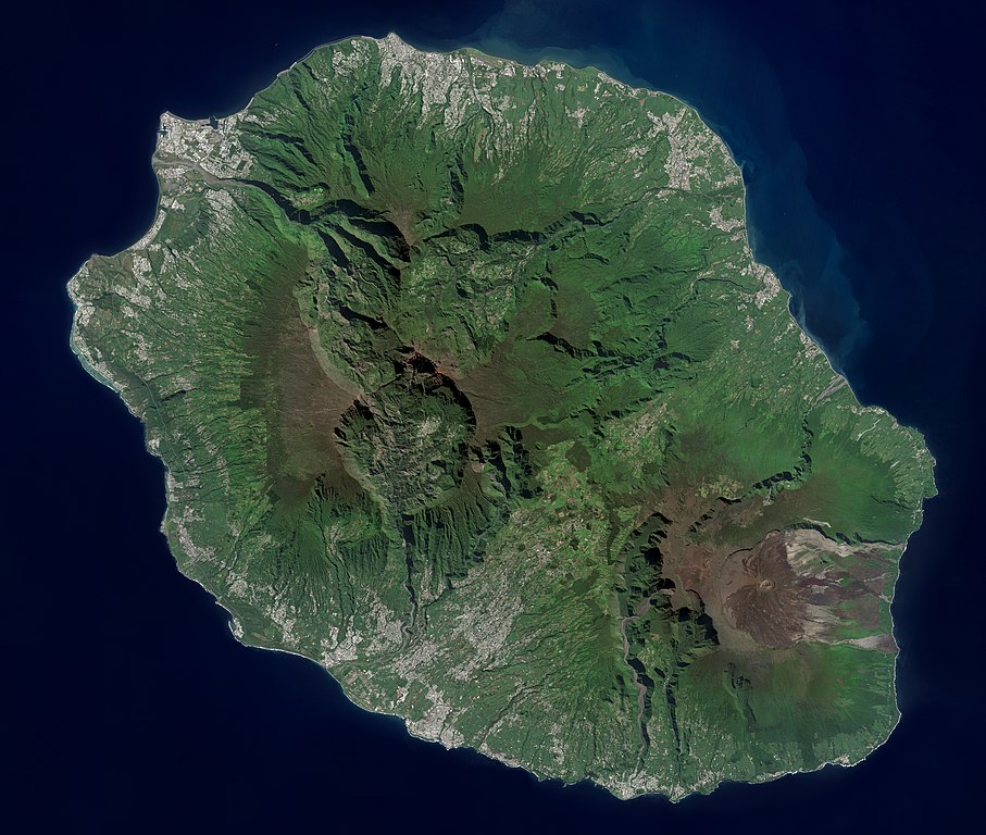
Français : L'île de la Réunion vue par le satellite Sentinel-2
English: Réunion island (Indian Ocean) photographed by Sentinel-2 satellite. |
| Dat | |
| Sous | https://phototheque.cnes.fr/cnes/media/68926 |
| Kreyatè | European Space Agency / CNES |
| Autres versions |

.jpg)
| Lieu de la prise de vue | | Voir cet endroit et d’autres images sur : OpenStreetMap |
|---|
.jpg¶ms=-21.134472_N_0055.247103_E_globe:Earth_type:camera__&language=ht)
Kondisyon itlizasyon

|
This image contains data from a satellite in the Copernicus Programme, such as Sentinel-1, Sentinel-2 or Sentinel-3. Attribution is required when using this image.
Rekonèt avèk non otè: Contains modified Copernicus Sentinel data 2021
The use of Copernicus Sentinel Data is regulated under EU law (Commission Delegated Regulation (EU) No 1159/2013 and Regulation (EU) No 377/2014). Relevant excerpts:
Free access shall be given to GMES dedicated data [...] made available through GMES dissemination platforms [...].
Access to GMES dedicated data [...] shall be given for the purpose of the following use in so far as it is lawful:
GMES dedicated data [...] may be used worldwide without limitations in time.
GMES dedicated data and GMES service information are provided to users without any express or implied warranty, including as regards quality and suitability for any purpose. |

|
Cette image a été promue selon les critères des images de valeur, et est considérée comme l’image de plus grande valeur sur Commons dans le domaine : Réunion island, France - satellite view.. La proposition est consultable sur Commons:Valued image candidates/L'île de la Réunion vue par le satellite Sentinel-2 (cropped).jpg. |
.jpg)
Istorik fichye a
Klike sou yon dat/yon lè pou wè fichye a jan li te ye nan moman sa a.
| Dat ak lè | Minyati | Grandè yo | Itilizatè | Komantè | |
|---|---|---|---|---|---|
| Kounye a | 6 septanm 2022 à 14:12 | | 5 000 × 4 232 (18,68 Mio) | Skimel | File:L'île de la Réunion vue par le satellite Sentinel-2.jpg cropped 15 % vertically using CropTool with precise mode. |
Itilizasyon fichye sa a
paj sa a itilize fichye sa a:
Itilizasyon global fichye a
Wiki sa a yo sèvi ak fichye sa a:
- Itilizasyon sou ar.wikipedia.org
- Itilizasyon sou arz.wikipedia.org
- Itilizasyon sou ast.wikipedia.org
- Itilizasyon sou az.wikipedia.org
- Itilizasyon sou ca.wikipedia.org
- Itilizasyon sou ce.wikipedia.org
- Itilizasyon sou cy.wikipedia.org
- Itilizasyon sou diq.wikipedia.org
- Itilizasyon sou es.wikipedia.org
- Itilizasyon sou es.wikivoyage.org
- Itilizasyon sou fr.wikinews.org
- Itilizasyon sou fr.wikivoyage.org
- Itilizasyon sou ga.wikipedia.org
- Itilizasyon sou gl.wikipedia.org
- Itilizasyon sou hy.wikipedia.org
- Itilizasyon sou ia.wikipedia.org
- Itilizasyon sou ig.wikipedia.org
- Itilizasyon sou ku.wikipedia.org
- Itilizasyon sou no.wikipedia.org
- Itilizasyon sou oc.wikipedia.org
- Itilizasyon sou pl.wikipedia.org
- Itilizasyon sou ps.wikipedia.org
- Itilizasyon sou tl.wikipedia.org
- Itilizasyon sou vec.wikipedia.org
- Itilizasyon sou vi.wikipedia.org
- Itilizasyon sou www.wikidata.org
.jpg)