Fichye:Ohrid Basin map.png

Dimansyon previzyalizasyon sa a : 420 × 599 piksèl. Lòt rezolisyon yo: 168 × 240 piksèl | 336 × 480 piksèl | 538 × 768 piksèl | 718 × 1 024 piksèl | 1 844 × 2 631 piksèl.
Fichye orijinal (1 844 × 2 631 piksèl, gwosè fichye a : 7,79 Mio, tip MIME li ye : image/png)
| Deskripsyon |
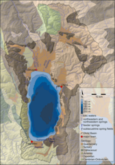
English: Map of the Ohrid Basin showing major hydrological and geological features. |
| Dat | |
| Sous |
Hauffe T., Albrecht C., Schreiber K., Birkhofer K., Trajanovski S. & Wilke T. (2011). "Spatially explicit analysis of gastropod biodiversity in ancient Lake Ohrid". Biogeosciences 8: 175–188. Figure 1. www.biogeosciences.net/8/175/2011/ doi:10.5194/bg-8-175-2011.
|
| Kreyatè | T. Hauffe, C. Albrecht, K. Schreiber, K. Birkhofer, S. Trajanovski & T. Wilke |
Ce fichier est disponible selon les termes de la licence Creative Commons Attribution 3.0 Non transposée.
- Ou gen dwa:
- pou pataje – pou kopye, distribiye epi difize ouvraj la
- pou remiks – pou adapte ouvraj la
- Selon kondisyon sa a yo:
- Rekonèt avèk non otè – Ou dwe bay enfòmasyon apwopriye sou otè a, bay yon lyen pou lisans lan, epi endike si te gen chanjman ki fèt. Ou ka fè sa nan nenpòt fason rezonab, men okenn fason ki sijere ke otè a soutni oswa apwouve itilizasyon ou an.
Istorik fichye a
Klike sou yon dat/yon lè pou wè fichye a jan li te ye nan moman sa a.
| Dat ak lè | Minyati | Grandè yo | Itilizatè | Komantè | |
|---|---|---|---|---|---|
| Kounye a | 13 mas 2015 à 21:30 | | 1 844 × 2 631 (7,79 Mio) | Snek01 | {{Information |Description={{en|Map of the Ohrid Basin showing major hydrological and geological features.}} |Source=Hauffe T., Albrecht C., Schreiber K., Birkhofer K., Trajanovski S. & Wilke T. (2011). "Spatially explicit analysis of gastropod biodive... |
Itilizasyon fichye sa a
Pa gen okenn paj ki itilize dosye sa a.
Itilizasyon global fichye a
Wiki sa a yo sèvi ak fichye sa a:
- Itilizasyon sou bg.wikipedia.org
- Itilizasyon sou de.wikipedia.org
- Itilizasyon sou el.wikipedia.org
- Itilizasyon sou en.wikipedia.org
- Itilizasyon sou mr.wikipedia.org
- Itilizasyon sou outreach.wikimedia.org
- Itilizasyon sou simple.wikipedia.org
- Itilizasyon sou vi.wikipedia.org
- Itilizasyon sou www.wikidata.org