Fichye:Philadelphia skyline from South Street Bridge January 2020 (rotate 2 degrees perspective correction crop 4-1).jpg

Dimansyon previzyalizasyon sa a : 800 × 200 piksèl. Lòt rezolisyon yo: 320 × 80 piksèl | 640 × 160 piksèl | 1 024 × 256 piksèl | 3 816 × 954 piksèl.
Fichye orijinal (3 816 × 954 piksèl, gwosè fichye a : 1,42 Mio, tip MIME li ye : image/jpeg)
Rezime
| Deskripsyon |
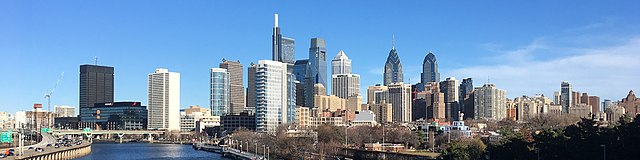
English: The skyline of Philadelphia, Pennsylvania viewed from the South Street Bridge over the Schuylkill River. If on Wikipedia, see the fully annotated version on the Wikimedia page.
|
||
| Dat | |||
| Sous | File:Philadelphia_skyline_from_South_Street_Bridge_January_2020.jpeg | ||
| Kreyatè | Dough4872; modifications and annotations by Maps and stuff (Brian W. Schaller) | ||
| Autres versions |
|

.jpg)
| Lieu de la prise de vue | | Voir cet endroit et d’autres images sur : OpenStreetMap |
|---|
.jpg¶ms=039.946975_N_-075.186797_E_globe:Earth_type:camera_heading:69.51&language=ht)
Kondisyon itlizasyon
Ce fichier est sous la licence Creative Commons Attribution – Partage dans les Mêmes Conditions 4.0 International.
- Ou gen dwa:
- pou pataje – pou kopye, distribiye epi difize ouvraj la
- pou remiks – pou adapte ouvraj la
- Selon kondisyon sa a yo:
- Rekonèt avèk non otè – Ou dwe bay enfòmasyon apwopriye sou otè a, bay yon lyen pou lisans lan, epi endike si te gen chanjman ki fèt. Ou ka fè sa nan nenpòt fason rezonab, men okenn fason ki sijere ke otè a soutni oswa apwouve itilizasyon ou an.
- Enfòmasyon sa yo ka pataje – Si ou fè rekopye, transfòme, oswa baze sou materyèl sa, ou dwe distribye kontribisyon ou anba menm oswa yon lisans konpatib avèk orijinal la.
| Annotations | Cette image est annotée : Voir les annotations sur Wikimedia Commons |
Istorik fichye a
Klike sou yon dat/yon lè pou wè fichye a jan li te ye nan moman sa a.
| Dat ak lè | Minyati | Grandè yo | Itilizatè | Komantè | |
|---|---|---|---|---|---|
| Kounye a | 27 janvye 2020 à 14:22 | 3 816 × 954 (1,42 Mio) | Maps and stuff | User created page with UploadWizard |
Itilizasyon fichye sa a
paj sa a itilize fichye sa a:
Itilizasyon global fichye a
Wiki sa a yo sèvi ak fichye sa a:
- Itilizasyon sou ang.wikipedia.org
- Itilizasyon sou ar.wikipedia.org
- Itilizasyon sou arz.wikipedia.org
- Itilizasyon sou ast.wikipedia.org
- Itilizasyon sou br.wikipedia.org
- Itilizasyon sou ca.wikipedia.org
- Itilizasyon sou ce.wikipedia.org
- Itilizasyon sou ckb.wikipedia.org
- Itilizasyon sou cy.wikipedia.org
- Itilizasyon sou da.wikipedia.org
- Itilizasyon sou de.wikivoyage.org
- Itilizasyon sou diq.wikipedia.org
- Itilizasyon sou en.wikipedia.org
- Itilizasyon sou en.wikibooks.org
- Itilizasyon sou en.wikivoyage.org
- Itilizasyon sou eu.wikipedia.org
- Itilizasyon sou fr.wikivoyage.org
- Itilizasyon sou ga.wikipedia.org
- Itilizasyon sou gl.wikipedia.org
- Itilizasyon sou ha.wikipedia.org
- Itilizasyon sou he.wikivoyage.org
- Itilizasyon sou ia.wikipedia.org
- Itilizasyon sou ilo.wikipedia.org
- Itilizasyon sou incubator.wikimedia.org
- Itilizasyon sou it.wikipedia.org
- Itilizasyon sou it.wikivoyage.org
- Itilizasyon sou ja.wikivoyage.org
- Itilizasyon sou kab.wikipedia.org
- Itilizasyon sou lb.wikipedia.org
- Itilizasyon sou lld.wikipedia.org
- Itilizasyon sou mhr.wikipedia.org
- Itilizasyon sou no.wikipedia.org
- Itilizasyon sou ru.wikipedia.org
- Itilizasyon sou ru.wikinews.org
- Itilizasyon sou simple.wikipedia.org
- Itilizasyon sou sr.wikipedia.org
Gade plis itilizasyon global fichye sa a.
.jpg)
.jpg)