Fichye:Vermilion Ohio aerial view.jpg
Dimansyon previzyalizasyon sa a : 800 × 533 piksèl. Lòt rezolisyon yo: 320 × 213 piksèl | 640 × 427 piksèl | 1 024 × 683 piksèl | 1 500 × 1 000 piksèl.
Fichye orijinal (1 500 × 1 000 piksèl, gwosè fichye a : 809 kio, tip MIME li ye : image/jpeg)
| Deskripsyon |
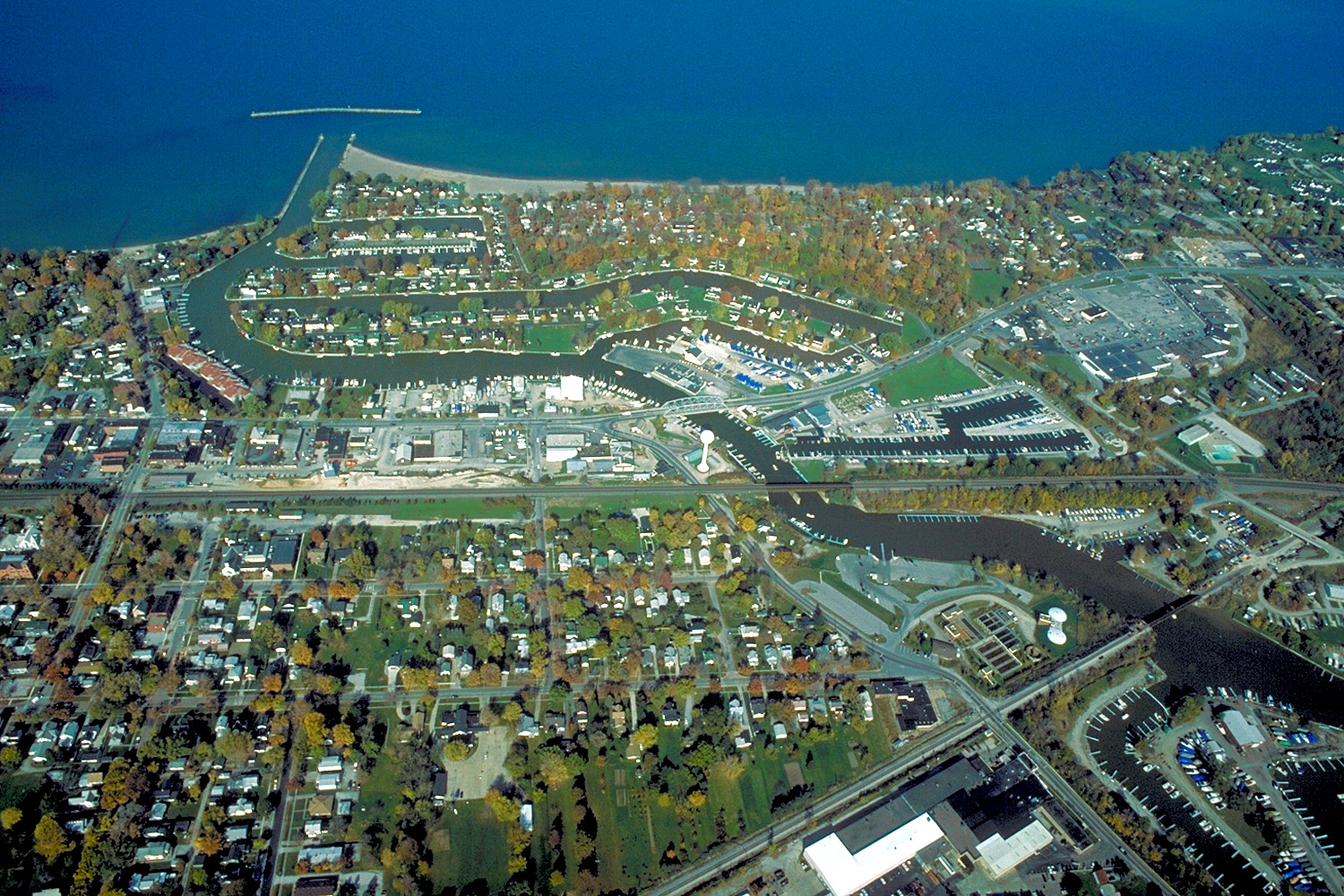
English: Aerial view of Vermilion, Ohio, USA on Lake Erie, near Sandusky, Ohio. The major highway U.S. Route 6 (Liberty Avenue) can be seen running west-east. |
|||
| Dat | ||||
| Sous |
U.S. Army Corps of Engineers Digital Visual Library Image page Image description page Digital Visual Library home page |
|||
| Kreyatè | Ken Winters, U.S. Army Corps of Engineers | |||
| Pèmisyon : (Resèvi ak fichye sa a) |
|
|||
| Lieu | Vermilion, Ohio, USA |
| Lieu de la prise de vue | | Voir cet endroit et d’autres images sur : OpenStreetMap |
|---|
Istorik fichye a
Klike sou yon dat/yon lè pou wè fichye a jan li te ye nan moman sa a.
| Dat ak lè | Minyati | Grandè yo | Itilizatè | Komantè | |
|---|---|---|---|---|---|
| Kounye a | 24 mas 2007 à 22:02 | | 1 500 × 1 000 (809 kio) | DanMS | {{Information | Description = {{en|Aerial view of Vermilion, Ohio, USA on Lake Erie, near Sandusky, Ohio. The major highway U.S. Route 6 (Liberty Avenu) can be seen running west-east, then turning to the northeast in the middle of the picture.}} | |
Itilizasyon fichye sa a
paj sa a itilize fichye sa a:
Itilizasyon global fichye a
Wiki sa a yo sèvi ak fichye sa a:
- Itilizasyon sou ar.wikipedia.org
- Itilizasyon sou arz.wikipedia.org
- Itilizasyon sou azb.wikipedia.org
- Itilizasyon sou ca.wikipedia.org
- Itilizasyon sou ceb.wikipedia.org
- Itilizasyon sou ce.wikipedia.org
- Itilizasyon sou cy.wikipedia.org
- Itilizasyon sou en.wikipedia.org
- Itilizasyon sou en.wikivoyage.org
- Itilizasyon sou es.wikipedia.org
- Itilizasyon sou eu.wikipedia.org
- Itilizasyon sou fa.wikipedia.org
- Itilizasyon sou fr.wikipedia.org
- Itilizasyon sou it.wikivoyage.org
- Itilizasyon sou ky.wikipedia.org
- Itilizasyon sou lld.wikipedia.org
- Itilizasyon sou pl.wikipedia.org
- Itilizasyon sou pt.wikipedia.org
- Itilizasyon sou simple.wikipedia.org
- Itilizasyon sou sr.wikipedia.org
- Itilizasyon sou sv.wikipedia.org
- Itilizasyon sou tr.wikipedia.org
- Itilizasyon sou tt.wikipedia.org
- Itilizasyon sou uk.wikipedia.org
- Itilizasyon sou vi.wikipedia.org
- Itilizasyon sou vo.wikipedia.org
- Itilizasyon sou www.wikidata.org
- Itilizasyon sou zh-min-nan.wikipedia.org